News Story
With MIPS funding, Herrmann and Azarm developing algorithm for ice forecasting app
Many driving accidents and deaths could be prevented if we had the ability to accurately detect icy road conditions and alert transportation authorities and drivers to these dangers. A new one-year Maryland Industrial Partnerships (MIPS) contract will enhance the weather app “IcyRoad” to take advantage of information from fleets of unmanned aerial vehicles (UAV) for more timely and accurate road condition predictions.
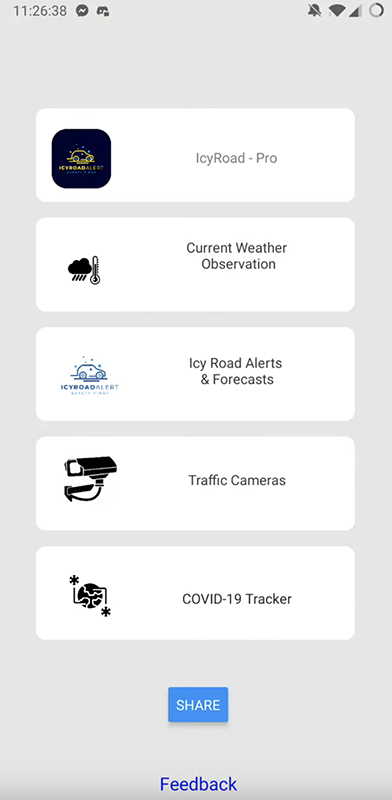
IcyRoad is a forecast and alert app that predicts the status of road ice for any road across the United States. It creates a map with a route showing which sections of the route are icy. IcyRoad reduces winter driving risk, enhances public awareness of the road conditions, and helps to reduce winter highway accidents.
Professor Jeffrey Herrmann (ME/ISR) and Professor Shapour Azarm (ME/AMSSC) are working with the Maryland small business SpringGem Weather Information on the project, “Routing Unmanned Aerial Vehicles for Detecting Highway Surface Conditions in Winter Weather.”
An IcyRoad user (such as staff in Maryland’s Department of Transportation, other state DOTs, cities, and airports) can deploy Unmanned Aerial Vehicles (UAVs or drones) that carry hyperspectral cameras to capture visible and near-infrared spectral reflectance from roadways. The IcyRoad system processes data from these UAVs to determine whether black ice is present on a roadway. Currently, the IcyRoad system does not include any routines for generating solutions that provide the user with suggested routes for the UAVs.
To enhance the IcyRoad system, SpringGem needs an algorithm to optimize use of UAVs to obtain as much useful information as possible given a fleet of UAVs with a limited range and current weather conditions (such as the magnitude and direction of winds, surface temperature, rainfall, clouds and humidity).
Operating in cold weather reduces UAV range because voltage drops rapidly when battery life gets low in these conditions. Although this UAV routing problem (URP) is related to the capacitated arc routing problem, it has distinctive features, and research is needed to develop and test algorithms that can generate solutions for the URP.
Professors Azarm and Herrmann have extensive experience in these types of routing problems, including problems with multiple UAVs. In this applied research MIPS project, they have teamed up with Dr. Menglin Jin from SpringGem to develop a route-constructing algorithm for a fleet of UAVs to measure designated road segments while taking into consideration current weather conditions. Solving this UAV routing problem will help determine a more accurate forecast of the road conditions in winter weather.
IcyRoad can be used with a web interface on a desktop computer or as an app available at the GooglePlay store and Apple App Store. The video below demonstrates the current version of the IcyRoad app.
About SpringGem Weather Information
SpringGem Weather Information focuses on integrating weather numerical forecasting, satellite and ground remote sensing, data science, and cloud computing to provide hyperlocal solutions for urban energy, traffic safety, agriculture monitoring, and environment-health assessment. The company has received funding from NSF I-Corps, NSF Small Business Innovation Research (SBIR), Maryland Technology Development Corporation’s (TEDCO) Maryland Innovation Initiative (MII), the Maryland Department of Transportation, NASA Earth Science, and private investors.
Published May 18, 2021
Related Stories
Stories / January 19, 2023
New algorithms for multi-robot systems in low communication...
Stories / January 5, 2023
ArtIAMAS receives third-year funding of up to $15.1M
Stories / July 21, 2022
UMD Team Wins Inaugural NIST UAS 3.1: FastFind Challenge
Stories / July 7, 2022
Alum Naomi Leonard is 2023 IEEE Control Systems Award recipient

Stories / October 20, 2021
Michael Fu part of NSF project to improve kidney transplant...

Stories / July 26, 2021
Rachel Suitor aboard NGS/NOAA expedition in Gulf of Mexico
Stories / June 2, 2021
UMD Takes Second in VFS Design-Build-Vertical-Flight Competition
Stories / May 26, 2021
UMD, UMBC, ARL Announce Cooperative Agreement to Accelerate AI,...

Stories / October 15, 2020
New hazard mitigation software moves UAVs closer to National...
Stories / July 15, 2025
Fischell Institute Hosts Maryland Department of Commerce...